Researchers have developed a method for monitoring river water levels around the clock. The low-cost sensor, for example, is appropriate for area-wide flood warning systems. Researchers at the University of Bonn have developed a method for monitoring river water levels around the clock. The low-cost sensor, for example, is appropriate for area-wide flood warning systems. The findings of the study were published in the journal Water Resources Research.
There are numerous methods for determining the level of a watercourse, ranging from very simple ones to advanced radar solutions. But there is a catch: most measuring devices can be damaged by direct exposure to high water levels, many do not allow continuous monitoring, remote reading is difficult, or they are simply too expensive.
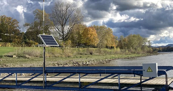
However, in Wesel on the Lower Rhine, a measuring device that does not have these drawbacks has already been in use for two years: It is inexpensive, dependable, and capable of continuously transmitting the water level to an evaluation center via mobile communication. In theory, this means that such a sensor is suitable for providing a densely distributed network for flood and drought warning systems.
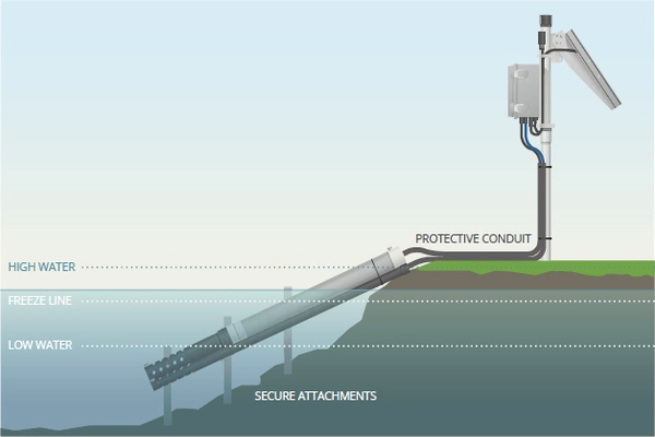
The core of our device is a low-cost GNSS receiver and antenna. This is a sensor that can conventionally determine the position of its location with several meter accuracy. However, satellite signals can also be used to measure the height of the GNSS antenna above the river surface.
Dr. Makan Karegar
“The core of our device is a low-cost GNSS receiver and antenna,” explains Dr. Makan Karegar of the Institute of Geodesy and Geoinformation at the University of Bonn. This is a sensor that can conventionally determine the position of its location with several meter accuracy. It does this using the US GPS satellites and their Russian counterparts, GLONASS. “However, satellite signals can also be used to measure the height of the GNSS antenna above the river surface,” Karegar says.
Reflected signals provide information on the water level
This is because the waves transmitted by the satellites are partially picked up directly by the antenna. The rest is reflected from the nearby environment (in this case the water surface) and reaches the receiver via detour. This reflected part therefore travels longer. When superimposed on the directly received signal, it forms certain patterns called interference. These can be used to calculate the distance between the antenna and the water level.
“We can attach the GNSS antenna to any structure, whether it’s a bridge, a building, or a tree or fence next to the river,” Karegar explains. “From there, it can measure the river level around the clock without contact – to within around 1.5 centimeters on average. And yet it is less likely to be damaged during extreme flooding events.” The accuracy of the method does not match that of a radar-based sensor. However, it is completely sufficient for the intended use. At just under 150 euros, the device is also considerably cheaper than its advanced counterpart.
The GNSS antenna is linked to a microcomputer known as a Raspberry Pi. “The device is about the size of a small smartphone, but it has enough power to calculate water levels from raw data,” says Prof. Dr. Kristine Larson of the Institute of Geodesy and Geoinformation. The microcomputer is very popular among hobbyists because of its flexibility and low power consumption. It can be powered by solar cells and then run completely on its own. It can also transmit data over a mobile network.
Reproduction information on the Internet
“We wrote open source software,” Larson says. “As a result, anyone can use it for free.” The researchers also make all project information available on the Internet. As a result, interested parties can easily replicate the measuring device.
The process, however, has one drawback: it is only suitable for rivers with a width of at least 40 meters. Karegar explains, “This is the smallest radius from which the antenna can receive the reflected satellite signal. The majority of the reflected signals come from the land if the watercourse is too narrow.”
However, those involved intend to improve their evaluation code. They hope that this will enable them to obtain reliable results for smaller rivers such as the Ahr in Germany, which experienced severe flooding in 2021.