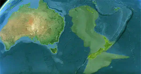
Zealandia has existed for around 60 million years, having separated from the supercontinent Gondwana at that period. It is also almost fully submerged underwater, and it was not officially acknowledged as a continent until 2017. However, it is currently undergoing a rebirth, at least in terms of research, as it becomes the first continent to be mapped while also exposing some new secrets.
Creating a complete map of a continent was challenging even before Zealandia was officially established; all of Earth’s continents include difficult-to-explore submerged shelves, therefore geological maps throughout the planet’s surface are sparse. The fact that 95 percent of Zealandia is submerged makes it the most difficult.
Fortunately, that did not deter researchers. Building on a report published in 2019, a multinational team of scientists successfully mapped the 5 million square kilometer (1.9 million square mile) continent.
“We believe Zealandia is the first of Earth’s continents to have its basement, sedimentary basins, and volcanic rocks fully mapped out to the continent-ocean boundary,” the team stated in a study summarizing the mapping and discoveries.
Previous studies found that Zealandia’s crust is thinner than the crusts of most other continents, but the cause of the thinning was unclear. Using magnetic surveys, the new study discovered an explosive probable cause: basalt lava rocks that indicated a massive volcanic zone.
This region is considered to have burned between 100 and 60 million years ago, around the time Zealandia separated from Gondwana. “For this period of at least 40 million years, molten magma flooded out of cracks and fissures as the continent stretched and thinned like pizza dough,” said lead author Nick Mortimer.
Wanda Stratford, a co-author, added: “Until recently, the role of magma in Gondwana’s disintegration has been underestimated. We can now see that these lavas cover 250,000 km2 [96,500 square miles] of the continent, which is roughly the size of New Zealand.”
The comprehensive map also provided a detailed image of another important aspect of Zealandia’s story, its 4000-kilometer-long (about 2,500-mile) granite backbone, thanks to dating and chemical studies. The Median Batholith, a transcontinental strip of granite, is considered to be 250-100 million years old.
Mortimer has some ideas for Zealandia’s next steps. “While the continent is the first to be entirely mapped to its undersea boundaries, there is still plenty to find and explore. Not simply where, but when, how, and why the great geological processes that shaped our continent occurred.