According to the World Meteorological Organization, the powerful weather phenomenon La Nia will persist for a third year in a row and may extend until the beginning of next year (WMO). Worldwide weather is expected to be impacted, from droughts in Africa to a rainy and wild summer in Australia.
The WMO has declared that they have forecast this current La Nia phase, which began in September 2020, will last for the following six months. It is predicted to continue through September–November 2022 with a 70% probability and through December–February 2022–2023 with a 55% probability.
Triple-year Even though they are relatively uncommon, La Nia incidents do occasionally occur. La Nia conditions normally endure less than a year, while they may extend for two years straight.
But three years is really unusual.
Only two instances of a “triple dip” of La Nia have been recorded since records began: from 1998 to 2001 and from 1973 to 1976. Some additionally mention the circumstances that existed between 1954 and 1957.
La Nia events occurring three years in a row is unusual, according to WMO Secretary-General Professor Petteri Taalas.
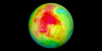
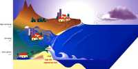
The El Nio-Southern Oscillation is a cycle that causes temperature changes in the tropical eastern Pacific Ocean. La Nia, which translates to “the girl” in Spanish, is the name given to the cooling phase, which is characterized by below-average sea surface temperatures in the east-central Pacific. El Nio, which translates to “the boy,” describes the warm period when the warmest surface waters of the Pacific Ocean are found off the coast of northern South America. In between phases, there is a neutral stage that takes place.
The wind, cloud, and pressure patterns over the Pacific are disturbed by these changes, which has a domino effect on the weather all around the world.
“La Nia is evident in the escalating drought in the Horn of Africa and southern South America as well as the region’s above-average rainfall. The severe drought in the Horn of Africa will worsen and afflict millions of people, according to the latest La Nia Update, which is unfortunate, Taalas said.
The east coast of Australia is expected to be most affected by the triple-year La Nia. Eastern Australia should be prepared for significant rainfall in spring and summer, according to the Bureau of Meteorology. Along with this, we can anticipate more severe flooding and even cyclones along the east coast.
“I’d bet my bottom dollar that flooding in eastern Australia will get worse over the next six months. A wet spring is predicted by the climate trends in the Pacific, Indian, and Southern Oceans. Any considerable rainfall will probably result in floods because the rivers and dams are already full, said Kimberley Reid, an atmospheric scientist at the ARC Centre of Excellence for Climate Extremes at Monash University.
“Given the predicted circumstances for the forthcoming season, there is a greater likelihood of severe cyclones and storms. According to Dr. Javier Leon, a geographer at the University of the Sunshine Coast, “in the worst case, we can expect levels of erosion equivalent to 1974 when conditions were identical with three back-to-back La Nia occurrences.”