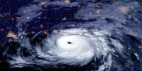
Over 2 million residences were left without power in the southwest of Florida as a result of Hurricane Ian, a category 4 hurricane that made landfall on Wednesday, September 28. You may think that flying would be the last thing you’d want to do with wind gusts of over 241 km/h (150 mph) reported, but the National Oceanic and Atmospheric Administration’s (NOAA) Hurricane Hunters don’t agree.
The Hurricane Hunters are airplanes with specialized equipment that fly right into storm’s eye. The information that the team can acquire utilizing these planes, which are essentially meteorological stations with wings, as well as some highly skilled experts, aids forecasters in making predictions and leads to a greater knowledge of these hazardous weather phenomena.
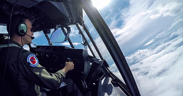
Engineer Nick Underwood of the NOAA Hurricane Hunters shared on Twitter his experience of flying into Hurricane Ian’s eye. Keep your hats on, because things are about to get quite bumpy.
Nick and the other members of the crew flew over the storm in the dependable N42RF, also known as “Kermit.” The WP-3D aircraft flies 8,000–10,000 feet (or 2,400–3,000 meters) above the water. The team uses a variety of methods to get this important data, including dropping dropsondes into the storm in addition to using their equipment. These weather gadgets, which are intended to be dropped from an aircraft, transmit radio data about the atmosphere they are falling into back to the aircraft.
Nick captured some amazing images from inside the storm’s eye, revealing just how much lightning was occurring. This is also visible from a satellite image, which aids in illustrating Hurricane Ian’s size.
You will feel seasick watching this saildrone footage of Hurricane Fiona if you want to see a category 4 hurricane from the sea level.