With alarm bells ringing about the Arctic Ocean’s rapid loss of sea ice, satellite data have revealed how warmer Atlantic waters are reducing ice regrowth in the winter. Furthermore, with seasonal ice becoming more unpredictable, ESA’s SMOS and CryoSat satellites are being used to improve sea-ice forecasts, which are critical for shipping, fisheries, and indigenous communities, among other things.
After the cold winter months, Arctic sea ice reaches a maximum around March and then shrinks to a minimum around September due to summer melt. These seasonal swings, however, are not only linked to the changing seasons—it has been discovered that, in addition to our warming climate, the temperature of adjacent ocean seawater is now also contributing to the ice’s vulnerability.
Previous research suggested that after a strong summer melt, sea ice could partially recover in the winter because thin ice grows faster than thick ice. However, new research indicates that heat from the ocean is outweighing this stabilizing effect, reducing the amount of sea ice that can regrow in the winter. This means that during warmer summers and winter storms, sea ice is more vulnerable.
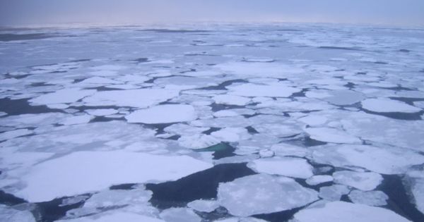
The amount of sea ice floating in the Arctic Ocean varies enormously as it grows and shrinks with the seasons. Although some of the older thicker ice remains throughout, there is an undeniable trend of declining ice as climate change tightens its grip on this fragile polar region.
The study, which was recently published in the Journal of Climate, describes how scientists used satellite data from ESA’s Climate Change Initiative to calculate changes in Arctic sea ice volume between 2002 and 2019.
Robert Ricker of Germany’s AWI Helmholtz Center for Polar and Marine Research and colleagues mapped regional changes in sea-ice volume due to drift and calculated how much ice grows each month due to freezing. They also used model simulations to investigate the causes of change, which backed up their findings.
“Over the last decades, we observed a tendency that the less ice you have at the beginning of the freezing season, the more it grows in the winter season,” Dr. Ricker said. However, we’ve discovered that in the Barents and Kara Sea regions, this stabilizing effect is being overwhelmed by ocean heat and warmer temperatures, which are reducing winter ice growth.”

This new process is known as Atlantification, and it refers to how heat from the Atlantic Ocean is being carried to higher latitudes, causing the sea ice to retreat. “Most importantly, this means that if we have a warm summer or strong winds, the sea ice will be less resilient,” Dr. Ricker added.
The researchers believe that the stabilizing mechanism in other Arctic regions may be overpowered in the future. While it is clear that continuing to monitor Arctic sea ice for evidence to support climate policies is critical, satellite observations are being used for practical purposes such as sea-ice forecasting.
The CryoSat mission’s ice-thickness data contributed significantly to the Atlantification findings, but the mission’s data, combined with data from the SMOS satellite, are also critical to improving forecasts of the thinner, more fragile thin sea ice.
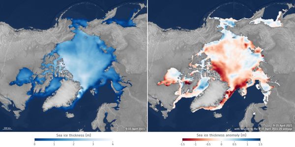
Every day, the Alfred Wegner Institute (AWI) in Germany combines weekly CryoSat data with daily SMOS data to produce a weekly-averaged product. These combined data, which are also used for forecasting, show that the volume of sea ice in the 2020-21 winter season was the lowest since these sea-ice data products began in 2010.
According to AWI’s Stefan Hendricks, “The region north of Greenland and the Canadian Archipelago, where the thickest ice usually resides, is the cause of this low volume of sea ice. Last winter, there was almost no thick sea ice. The remaining Arctic sea ice is a mixture of above and below average.”
Weather and climate forecasts may benefit from the information as well. Many seasonal forecasting centers provide dynamic sea ice predictions. While assimilating sea-ice concentration is common, constraining initial conditions of sea-ice thickness is still in its infancy. However, preliminary assimilation studies at the European Center for Medium-Range Weather Forecasts (ECMWF) show that the seasonal forecast system has improved significantly.
“Our results demonstrate the usefulness of new sea-ice observational products in both data assimilation and forecasting systems, and they strongly suggest that better initial sea-ice thickness information is crucial for improving sub-seasonal to seasonal sea-ice forecasts,” said Beena Balan Sarojini of the ECMWF.


