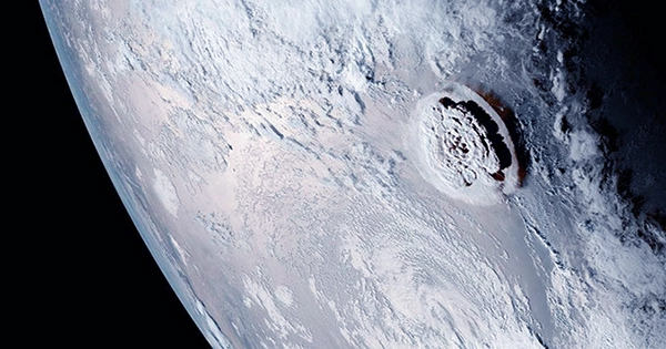
On Jan. 15, 2022, the Hunga Tonga-Hunga Ha’apai eruption reached a climax. Its rapid release of energy not only fueled an ocean tsunami that wreaked havoc as far as the West Coast of the United States, but it also created pressure waves in the atmosphere that soon spread throughout the globe. Close to the eruption, the airwave pattern was complex, but thousands of kilometers away, it appeared as a single wave front moving horizontally at almost 650 miles per hour as it stretched outward.
According to NASA’s James Garvin, chief scientist at the Goddard Space Flight Center, the blast was roughly 10 megatons of TNT equivalent, which is nearly 500 times more powerful than the bomb dropped on Hiroshima, Japan, during World War II. The wave looked like a ripple created by dropping a stone in a pond to satellites having infrared sensors above. As it passed over North America, India, Europe, and other parts of the world, the pulse was detected as changes in air pressure that lasted several minutes. People were able to track the pulse’s movement in real-time online as observers shared their barometer findings on social media. In just 35 hours, the wave had traveled around the planet and returned.
For nearly four decades, I have researched the oscillations of the global atmosphere as a meteorologist. The Tonga eruption’s wavefront expansion was a particularly remarkable example of the phenomena of worldwide atmospheric wave propagation, which has been observed following numerous historic explosive events, including nuclear tests. This eruption was so powerful that it rang like a bell in the atmosphere, yet at a frequency too low to hear. A phenomenon been studied for over 200 years.
The massive eruption of Mount Krakatoa in Indonesia in 1883 generated the first such pressure wave that drew scientific attention. Barometric studies at many locations around the world revealed the Krakatoa wave pulse. Of course, communication was slower back then, but within a few years, scientists had compiled all of the individual observations and were able to plot the propagation of the pressure front on a globe map in the hours and days following the eruption.
The wavefront moved outward from Krakatoa, making at least three complete circumnavigations of the earth. In a famous 1888 report on the eruption, the Royal Society of London released a series of maps depicting the propagation of the wavefront.


