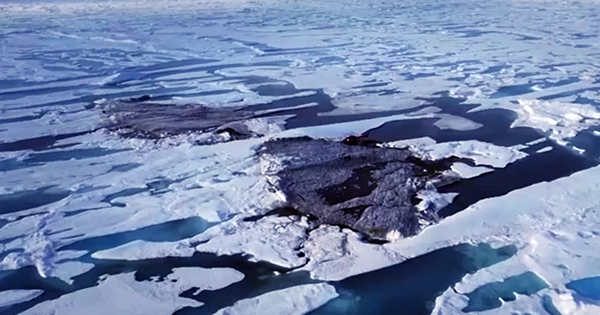
An expedition in 2021 discovered what appeared to be an undiscovered island off the coast of frigid northern Greenland. It was described as a contender for the title of the world’s most northerly known land mass and was modest and gravelly in appearance. It was given the Greenlandic name Qeqertaq Avannarleq, which means “the northernmost island” in English.
However, there was a mystery going on in the area. Several more tiny islands to the north of Cape Morris Jesup had been found throughout the years, only to vanish.
Some researchers hypothesized that these were stony banks that sea ice had pushed up.
However, when a group of surveyors from Switzerland and Denmark ventured up north to look into this “ghost islands” phenomenon, they found something very different. Their conclusions were released in September 2022: These enigmatic isles are actually enormous icebergs that have become anchored to the ocean floor. They most likely originated from a nearby glacier where other just calved icebergs were prepared to float out since they were covered in gravel from landslides.
This was not the first time that territory had to be removed from a map in the high Arctic or that such a disappearing act had occurred. Large portions of the Barents Sea’s charts were completely redrawn by an inventive aerial mission over a century ago.
The zeppelin’s perspective in 1931: The 1931 expedition was conceived as a grand publicity ploy by American newspaper tycoon William Randolph Hearst.
Hearst suggested that the submarine that would journey beneath the ice and the Graf Zeppelin, the largest airship in the world at the time, meet at the North Pole. A worldwide polar research group took up the idea of deploying the Graf Zeppelin to conduct geographic and scientific investigations of the high Arctic after Hearst abandoned the plan due to logistical issues.
They planned an aerial expedition that would use cutting-edge technology to make significant geographic, meteorological, and magnetic discoveries in the Arctic, as well as remap a significant portion of the Barents Sea.
The expedition was dubbed Polarfahrt, which is German for “polar voyage.” The zeppelin carried a group of scientists and explorers from Germany, the Soviet Union, and the United States despite the current state of global unrest.
One of them was wealthy American and seasoned Arctic explorer Lincoln Ellsworth, who would compose the first scientific account of the Polarfahrt and its geographical discoveries. The excellent meteorologist Pavel Molchanov and the expedition’s lead scientist, Rudolf Samoylovich, who conducted magnetic measurements, were two other notable Soviet scientists that took part in the voyage. Ludwig Weickmann, the head of the Geophysical Institute of the University of Leipzig, was in charge of the weather operations.
Arthur Koestler, a teenage journalist who would later become well-known for his anti-communist book “Darkness at Noon,” which showed tyranny turning on its own party members, served as the expedition’s chronicler.
We spent several days hovering in the Arctic air, traveling at a leisurely average speed of 60 miles per hour and frequently stopping in midair to finish a photographic survey or launch tiny weather balloons. In an age of speed boats, it all had the beauty and low-key exhilaration of a voyage on the final sailing ship.
The negative effects of not existing: The high latitude areas that the Polarfahrt traveled through were quite isolated. There had been some skepticism regarding Franz Josef Land’s existence until Austrian explorer Julius von Payer announced the discovery of the archipelago of approximately 200 islands in the Barents Sea.
Franz Josef Land’s presence was proved by the Polarfahrt, but it also showed that the early high Arctic explorers’ charts had stunning errors.
The Graf Zeppelin was equipped with wide-angle cameras for the voyage, enabling comprehensive pictures of the ground below. The leisurely surveys that could be made from the Zeppelin’s leisurely motion were appropriate for this purpose and were not possible from fixed-wing aircraft overflights.
The remainder of July 27 was spent, according to Koestler, “doing a geographical survey of Franz Josef Land.”
“An island called Albert Edward Land was our initial target. However, given that Albert Edward Land had the drawback of not existing, it was easier said than done. It was shown on every map of the Arctic, although it wasn’t actually there.
“The next goal is Harmsworth Land. As absurd as it may sound, Harmsworth Land wasn’t real either. Where it should have been, there was only the black polar sea and the white Zeppelin’s reflection.
“Who knows if the discoverer who put these islands on the map (Payer, I suppose) was duped into thinking that certain icebergs were actual land? In any case, they were formally forgotten as of July 27, 1931.
Six new islands would be found during the voyage, and many more coastlines would be redrawn.
A novel method of measuring the atmosphere: Additionally noteworthy about the mission were the instruments Molchanov tested on board the Graf Zeppelin, including his recently developed “radiosondes.” His innovations led to the development of tools that atmospheric scientists like me still rely on today, revolutionizing meteorological observations.
Up until 1930, it was extremely difficult for meteorologists to measure the temperature high in the atmosphere.
They employed so-called registering sondes, which deployed weather balloons to record the temperature and pressure. On paper or some other surface, a stylus would leave a continuous mark, but in order to interpret it, scientists would need to locate the sonde package after it had fallen, and it often drifted far from the launch site. Particularly in isolated regions like the Arctic, this was not viable.
Throughout the balloon flight, Molchanov’s equipment could radio back temperature and pressure readings at regular intervals. Today, hundreds of stations around the world launch balloon-borne radiosondes every day.
Molchanov had the opportunity to put up a magnificent performance during the Polarfahrt. The Graf Zeppelin typically flew in the lowest few thousand feet of the atmosphere, but it could also be used as a launch pad to send weather balloons considerably higher into the atmosphere, where they could function as remote reporting “robots” that could report back to earth.
The stratospheric temperatures close to the pole were originally seen by Molchanov’s hydrogen-filled weather balloons. Surprisingly, he discovered that the air at the pole was actually warmer than the air at the equator at heights of 10 miles.
The fate of the main characters: At the start of the 1930s, a time marked by a disastrous rise in authoritarian politics and international strife, the Polarfahrt represented the last great triumph of international scientific cooperation. Germany, the Soviet Union, and the United States would all be at war by 1941.
Stalin’s secret police claimed Molchanov and Samoylovich as victims. As a Hungarian Jew, Koestler would have his life and career shadowed by the politics of the age. He finally sought asylum in England, where he established himself as a novelist, essayist, and science historian.
The Graf Zeppelin continued to carry passengers on commercial flights, primarily transatlantic journeys. But the heyday of zeppelin travel was quickly put an end by one of history’s most famous disasters. The Hindenburg, the Graf Zeppelin’s younger sister airship, caught fire as it attempted to land in New Jersey in May 1937. In order to supply Germany’s war effort with scrap metal, the Graf Zeppelin was disassembled in 1940.