Peninsular Block in Indian Subcontinent
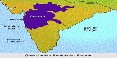
The Indian Subcontinent constitutes a distinguishing geographic entity that can be separated into three geomorphic provinces: (a) the Indian Peninsula, (b) the Himalayas, and (c) the Indo-Gangetic Alluvial Plains. The Peninsular Plateau of India is also named as the Plateau of Peninsular India. It is one of the main physiographic elements of India. The northern boundary of the Peninsular Block may be taken as an irregular line running from Kachchh along the western flank of the Aravali Range near Delhi and then roughly parallel to the Yamuna and the Ganga as far as the Rajmahal Hills and the Ganga delta. Apart from these, the Karbi Anglong and the Meghalaya Plateau in the northeast and Rajasthan in the west are also extensions of this block. The northeastern parts are separated by the Malda fault in West Bengal from the Chotanagpur plateau. In Rajasthan, the desert and other desert-like features overlay this block. The Indian Peninsula is a triangular-shaped landscape of earliest landmass with a record of a prolonged history of erosion, denudation, and resurgent tectonic activities. The plateau ascends 100 meters in the north, ascending further to over 1,000 meters to the south, creating a prominent triangle located in the well-known downhill-moving triangle of the seashore of the Indian subcontinent. Its origin lies in the collision of Indian and Eurasian plates around 15 million years ago.
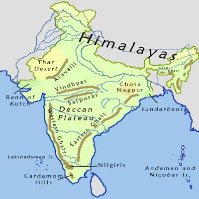
The Peninsular Block is created fundamentally by a great complex of very earliest gneisses and granites. Peninsular Block is an Indian plate which was earlier part of the Gondwana land/plate, which broke in geological time and broken parts of it move in the different directions as Indian plate, Australian plate, Antarctica plate, African plate, etc. The Peninsula is formed essentially by a great complex of very ancient gneisses and granites, which constitutes a major part of it. The Peninsular Block generally consists of relicts and residual mountains like the Aravali hills, the Nallamala hills, the Javadi hills, the Veliconda hills, the Palkonda range, the Mahendragiri hills, etc.
The present-day geomorphic distinctiveness of the whole territory has resulted because of more recent block uplift-type tectonic activities. Since the Cambrian period, the Peninsula has been standing like a rigid block with the exception of some of its western coasts which is submerged beneath the sea and some other parts changed due to tectonic activity without affecting the original basement. As a part of the Indo-Australian Plate, it has been subjected to various vertical movements and block faulting. The rift valleys of the Narmada, the Tapi and the Mahanadi and the Satpura block mountains are some examples of it. The Peninsula mostly consists of relict and residual mountains like the Aravali hills, the Nallamala hills, the Javadi hills, the Vcliconda hills, the Palkonda range, and the Mahendragiri hills. etc. The river valleys here are shallow with low gradients. To the south of the Satpura Mountain Range, the Indian peninsula is known as the Deccan Plateau.
Most of the cast flowing rivers form deltas before entering into the Bay of Bengal. The deltas formed by the Mahanadi, the Krishna, the Kaveri, and the Godavari are important examples.
