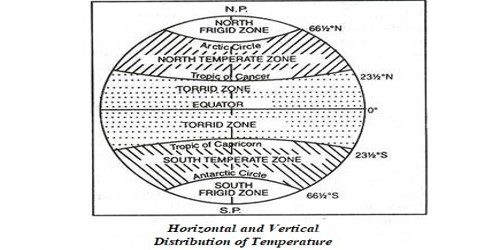
Horizontal and Vertical Distribution of Temperature
Horizontal Distribution of Temperature
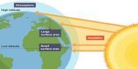
Distribution of temperature across the latitudes over the surface of the earth is called its horizontal distribution. When we evaluate an isotherm map, it can be seen that the horizontal distribution of temperature is uneven. The factors responsible for the uneven distribution of temperature are as follows: (i) Latitude, (ii) Land and Sea Contrast, (iii) Relief and Altitude, (iv) Ocean Currents, (v) Winds, (vi) Vegetation Cover, (vii) Nature of the soil, (viii) Slope and Aspect.
(b) Vertical Distribution of Temperature
The permanent snows on high mountains, even in the tropics, specify the reduction of temperature with altitude. This vertical gradient of temperature is commonly referred to as the standard atmosphere or Normal Lapse Rate. Observations expose that there is a quite normal decrease in temperature with an increase in altitude. However, this normal lapse rate varies with height, season, latitude and other factors. Indeed the real lapse rate of temperature does not constantly show a decline with altitude.
Explanation
The temperature-depth profile for the ocean water shows how the temperature decreases with the increasing depth. The profile shows a boundary region between the surface waters of the ocean and the deeper layers. The boundary usually begins around 100 – 400 m below the sea surface and extends several hundred of ‘m’ downward (Figure). This boundary region, from where there is a rapid decrease in temperature, is called the thermocline. About 90 percent of the total volume of water is found below the thermocline in the deep ocean. In this zone, temperatures approach 0° C.
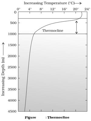
The temperature structure of oceans over middle and low latitudes can be described as a three-layer system from the surface to the bottom.
The first layer represents the top layer of warm oceanic water and it is about 500m thick with temperatures ranging between 20° and 25° C. This layer, within the tropical region, is present throughout the year but in mid-latitudes, it develops only during summer.
The second layer called the thermocline layer lies below the first layer and is characterized by a rapid decrease in temperature with increasing depth. The thermocline is 500 -1,000 m thick.
The third layer is very cold and extends up to the deep ocean floor. In the Arctic and Antartic circles, the surface water temperatures are close to 0°C and so the temperature change with the depth is very slight. Here, only one layer of cold water exists, which extends from surface to deep ocean floor. The average temperature of surface water of the oceans is about 27°C and it gradually decreases from the equator towards the poles. The rate of decrease of temperature with increasing latitude is generally 0.5°C per latitude. The average temperature is around 22°C at 20° latitudes, 14° C at 40° latitudes and 0° C near poles. The oceans in the northern hemisphere record relatively higher temperatures than in the southern hemisphere. The highest temperature is not recorded at the equator but slightly towards the north of it. The avenge annual temperatures for the northern and southern hemispheres are around 19°C and 16°C respectively. This variation is due to the unequal distribution of land and water in the northern and southern hemispheres.