A team of scientists from the University of RUDN and the Dokuchyaev Soil Science Institute have developed a system for the detection of soil color at various depths and soil profile composition using ground-penetrating radar. Using this approach, scientists may define the chemical composition of the soil and label it for possible use in manufacturing, agriculture, or mining without digging soil parts. The findings of the analysis were published in the journal Eurasian Soil Science.
Soil properties could be identified at any depth using radar. Scientists suggested a way to measure soil properties at any depth without digging.
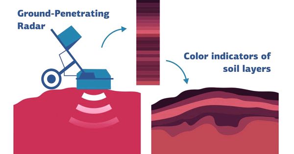
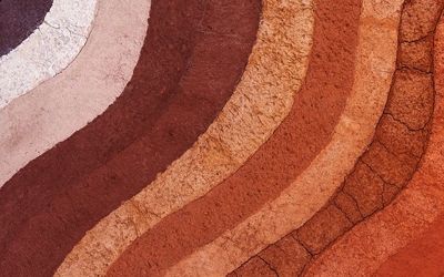
Color is one of the key markers of soil characteristics. Based on this, a professional may classify the soil type, humus content, soil density, temperature, salinity, and so on. For eg, black soil is rich in humus, and soils with an increased iron content appear to have a reddish hue. In order to examine the color of the soil, scientists need to dig a soil segment that is very labor-intensive. A team of scientists from the RUDN University, along with their colleagues from the Dokuchyaev Soil Science Institute, proposed using ground-breaking radar to determine the color of the soil at various depths. The GPR sends electric waves to the soil and reports a reflected signal.
“Color is one of the core properties of soils and have been used for their description for a long time. That’s why a lot of soil names are synonymous with color. In addition, color is an integral measure of many other soil characteristics. Theoretically, this parameter can be calculated with GPR. We wanted to confirm the connection between soil layer colors and GPR profile results,” said Prof. Igor Savin, Academician of the Russian Academy of Sciences and Ph.D. in Agricultural Sciences at the Faculty of Ecology, RUDN University.
The team performed an experiment in Kamennaya Steppe (Voronezh Region) since this area is known for a wide range of soil types and conditions. Scientists selected seven locations and searched the soil with ground-penetrating radar. They also obtained 30 soil samples from each site: one from each 10 cm deep layer down to a depth of 3 meters. The samples were dried and ground to identify the hue. To do so, the team analyzed their reflective power, which averaged three wavelength ranges: red (610-700 nm), green (520-540 nm), and blue (520-540 nm) (450-475 nm).
After that, the team correlated radar readings with soil samples and established a correlation model. In 80 percent of instances, the colors measured using the formula mirrored the real colors. The new approach can then be used to assess soil color at other sites in the research region without digging the soil sections. At present, the model is only applicable to the region of Kamennaya Steppe since it was calibrated on the basis of the samples obtained there. The team hopes to extend it to other places in the future.
“Our patterns cannot be used in regions with varying soil coverage. It is not, therefore, a drawback, but rather a peculiarity of our system. To ensure the accuracy of the models, the model should provide details on soil colors that are common for the study area. In the early stages, the soil management portions will also have to be carried out using conventional techniques. However, as soon as we collect enough field data, we will be able to do away with this phase, and no digging would be needed to classify soil color at any depth,” added Prof. Igor Savin of the University of RUDN.