Monsoon Winds of the Arabian Sea in Indian Subcontinent
The Southwest Monsoon season in India starts with the onset of the Southwest Monsoon winds in June and continues till the middle of September. As a result of the rapid increase of temperature in May over the northwestern plains, the low-pressure conditions over there get further intensified.
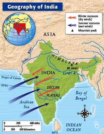
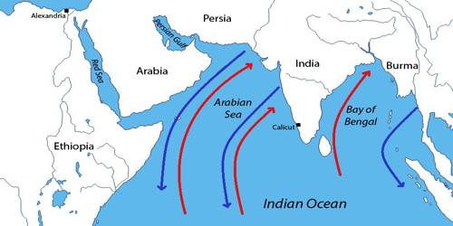
Over the Arabian Sea, monsoon winds alternately blow from the northeast and the southwest, reversing their dominant direction with the seasons. In the winter, the winds blow from Southwest Asia toward the sea.

The monsoon winds originating over the Arabian Sea further split into three branches:
(i) Its one branch is obstructed by the Western Ghats. These winds climb the slopes of the Western Ghats from 900-1200 m. Soon, they become cool, and as a result, the windward side of the Sahyadris and Western Coastal Plain receive very heavy rainfall ranging between 250 cm and 400 cm. After crossing the Western Ghats, these winds descend and get heated up. This reduces humidity in the winds. As a result, these winds cause little rainfall cast of the Western Ghats. This region of low rainfall is known as the rain-shadow area.
(ii) Another branch of the Arabian Sea monsoon strikes the coast north of Mumbai. Moving along the Narmada and Tapi River valleys, these winds cause rainfall in extensive areas of central India. The Chotanagpur plateau gets 15 cm rainfall from this part of the branch. Thereafter, they enter the Ganga plains and mingle with the Bay of Bengal branch.
(iii) The third branch of this monsoon wind strikes the Saurashtra Peninsula and the Kachchh. It then passes over west Rajasthan and along the Aravallis, causing only a scanty rainfall. In Punjab and Haryana, it too joins the Bay of Bengal branch. These two branches, reinforced by each other, cause rains in the western Himalayas.


